Well it was close, very close, too close to call; but after two weeks the votes have finally been counted. The nation can move on.
Feeling like an independent after 2 weeks of intense lobbying, I can now announce that the winner of the XmasEpic host destination for 2010 is ….
The North Coast
Traditional, provocative, cosmic, epic and psychedelic; the north coast of New South Wales screams: road bike, road trip.
Like a mandala broken only by the bits that make this loop incomplete, the XmasEpic trip will be a voyage of self-discovery.
We will negotiate the befuddled casualties of the ’60s, channel past lives (typically previous tour winners), and ride with legs like the very hardest red cedar of the border ranges.
In keeping with tradition (and provocation, cosmology and epicness) we will rise before the sun to thwart the heat, drink free trade’s finest and eat through countless bakeries. Let’s look at the World Heritage itinerary:
| Day | Route | Dist | Up(Down) | Accommodation |
| 1: Tues 11/1/11 | Ipswich – Wallace Creek | 58.9 | 434(346) | Boonah Eco Cottage |
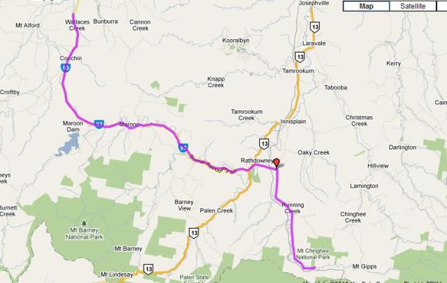
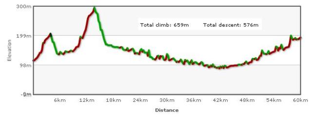
| 2: Wed 12/1/11 | Wallace Creek – Mt Chinghee | 60.0 | 659(576) | Andrew Drynan Camp Ground |
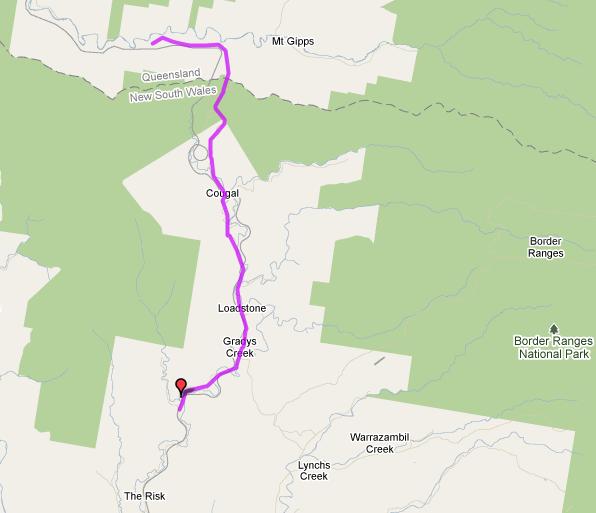
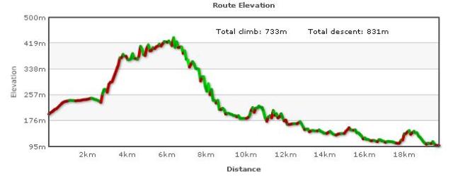
| 3: Thurs 13/1/11 | Mt Chinghee – Mt Lion | 19.6 | 733(831) | Rainforest Gateway CP |
| 4: Fri 14/1/11 | Mt Lion – Lismore | 71.3 | 473(560) | Lismore Palms CP |
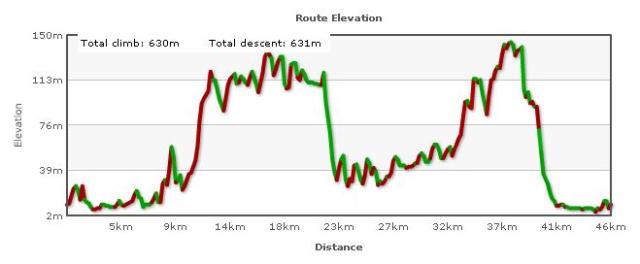
| 5: Sat 15/1/11 | Lismore – Byron | 45.8 | 630(631) | Belongil Fields CP |
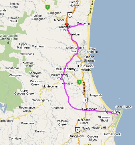
| 6: Sun 16/1/11 | Byron – Wooyung | 42.3 | 611(615) | Wooyung Beach CP |
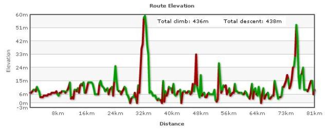
| 7: Mon 17/1/11 | Wooyung – Helensvale | 80.7 | 436(438) | Brisbane |
| Total | 379 |
And introducing the following innovation: alternative routes for those that want extra epicness:
| Day | Route | Dist | Up(Down) | Accommodation |
| 2A: Wed 12/1/11 | Wallace Creek – Mt Barney | 45 | 602 (517) | |
| Mt Barney walk | ~10 | 1000 (1000) | Mt Barney Lodge | |
| 3A: Thurs 13/1/11 | Mt Barney – Mt Lion | 83.3 | 967 (1065) | Rainforest Gateway CP |
| 7A: Mon 17/1/11 | Wooyung – Helensvale | 107 | 883 (885) | Brisbane |
The North Coast Trip
Keywords:
An optimal mix of traditional rolling hills through the verdant Queensland boondocks, the epic passes of the border ranges, through psychedelic jungle more real than a Costa Rica Survivor reality show, passing the romantic lush greenery of the northen rivers, the ultra beaches of the idle unemployed, and provocative bling of the Gold Coast.
Timing:
Meet Monday (10/01/11) afternoon at our place. Load car. Check bikes. We provide floor/couch space for those wanting accommodation. Sunrise 5:03am (QLD time). Ride to Toowong, trains to Ipswich leave 5:16 and 5:57.
Return via train to Toowong on Monday (17/01/11) evening. Again our orthopedic floor is available that night. TDU participants will need a quick transfer to Adelaide.
Day 1 Ipswich – Wallace Creek: 59 km bikely map
Take the train to Ipswich. Approx. 5 km of reasonably busy road, then quiet backroads to Wallaces Creek. I think 2nd Breakfast Harrisville (27km) and 1st Lunch Boonah (51km). “Destiny” Boonah eco-cottage Donkey Farm. Rent for the “Red Cottage” is $280 or ~$35 each.
701 Boonah Rathdowney Road, Wallace Creek QLD 4310. (07) 5463 2643 http://ecocottage.com.au/


Day 2 Wallace Creek – Mt Chinghee: 60 km bikely map
Up and down two early hills then on into Rathdowney for 2nd breakfast (28 km). From there Running Creek Rd, then the Lions road. Arrive in time for early lunch at campsite at Andrew Drynan park on banks of Running Creek, next to Mt Chinghee. $5 pp. No food. No showers.
Day 3 Mt Chinghee – Mt Lion: 20 km bikely map
A short 20km, but up and over the border ranges. 2nd Breakfast at Border or Cougal. We pass the famous spiral railway loop. The Lions Rd is a low traffic “unofficial” road, following the original convict Rd, sealed by Lions Club. Rainforest Gateway CP in the fork of Gradys Ck and Cedar Cutters Ck. No food. tents site: $20/family, units $60/5p, cottage $70/5p.
Grady’s Creek, Mt. Lion.
http://www.visitkyogle.com.au/index.php/accommodation_details/rainforest_gateway_caravan_park/
Day 4 Mt Lion – Lismore: 71 km bikely map
Power down to the flat past “The Risk” and onto a 2nd Breakfast at Kyogle. Then the low traffic Bentley Rd to Lismore. To the shores of Wilsons River where they say you can catch an Australian Bass from your tent site. Cabins & tent sites cost:?
Lismore Palms Caravan Park
42-58 Brunswick Street, Lismore, (02) 6621 7067.
http://www.lismorepalms.com.au/
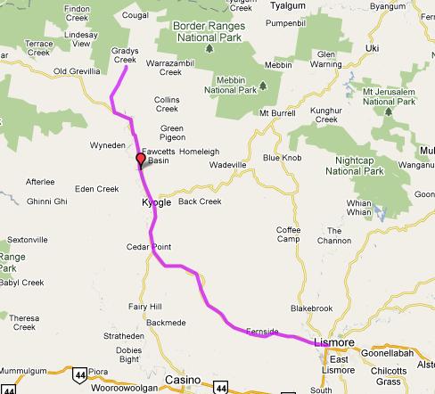

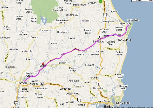
Day 5 Lismore – Byron: 46 km bikely map
Along the Bangalow Rd. 2nd Breakfast at Clunes (17km), 1st Lunch and Bangalow (31 km). We then hit the sea and cafes at Byron.
cabin $160/2p, tent sites: $50/2p
Belongil Fields CP
394 Ewingsdale Rd, Byron Bay, (02) 6680 8999
http://www.belongilfields.com.au/
Day 6 Byron – Wooyung: 42 km bikely map
Off the highway to Mullumbimby Madness for 2nd Breakfast (21 km). Then follow parts of the old hwy (at no stage are we on the main hwy), then back to coast to Wooyung. tent sites: $24/2p; motel rooms $80/2p.
Wooyung Beach Holiday Park
515 Wooyung Rd, Wooyung, (02) 6677 1300
http://wooyungbeach.com.au/

Map 7 Wooyung – Helensvale: 81 km bikely map
A leisurely pedal up the flat coast roads o the border. 2nd Breakfast Kingscliff (24 km).
Tricky manoeuvres to cross Tweed River (see below), or alternative Day 7 Epic Epic. Run through main strip of Surfers. Catch train from Helensvale back to luxurious Brisbane accommodation.

Alternative routes:
For those feeling particularly epic, days 2 & 3 and day 7 can be replaced with the following, which includes a climb up Mt Barney. They rejoin the rest of us at the end of days 3 and 7 respectively.
Alternative Day 2 Wallace Creek – Mt Barney: 45 km bikely map
A 45km ride before breakfast then a climb(walk) up Mt Barney(~10km, 1000m). This is one of the great one day walks in Australia, and suitably epic. Definitely will give one the opportunity to say “shut up legs”. The peasants walk up the south ridge is the “easiest” way. Nat Parks map here. It takes 8 hours minimum, although we can save some time by riding in along the flat first 6 km from the YellowPinch car park. Those doing this option would stay at Mt Barney Lodge near base of Mt Barney. (Or the campground at the base. You wont want to be riding any distance after the walk.) tent sites: $12pp, cabins $120/2p, trailer cabin $80/2p.
Mt Barney Lodge
1093 Upper Logan Rd, Mt Barney, (07) 5544 3233
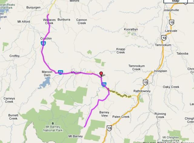

Alternative Day 3 Mt Barney – Mt Lion: 83 bikely map
Requires a longish ride along Mt Lindesay Hwy, which has more traffic than The Lions Road. Also the pass over the border ranges require more climbing. Rejoin main group at Mt Lion.


Alternative day 7 Wooyung – Helensvale: 107 bikely map
The ride over the border ranges at Mt Tomewin and down the Currumbin valley is one of the iconic rides of the area.


Fan jolly tastic Mark! It is as ever organised with precision and great flare. I will do my bit by organising a cold front mid Jan.
Am now encouraging discussion of food allergies, special diets, intolerances, preferences (or will toast and vegemite do?) Have the coffee pots organised and ready to go.
great flare sounds intriguing … have we coincided with an auspicious date?
A sun or fire festival?
Yes, we leave on 11/1/11! and I’m thinking blood sacrifice to appease the cycle gods.
The ammendments to days 1 & 2 have been made, bikely maps updated.
Tour now entails an epic 54km / day.
I have stocked the freezer with sherpa blood so we can all do infusions the night before. It’s a power for the hills.
I’m just wondering about the wisdom of having an 81km leg, with a fair bit of climbing, on the first day, keeping in mind the desirability of making an early start cycling to beat the heat. By the time everyone gathers after a train trip for the start of cycling, an early start on the road will be difficult. It’s the longest day riding in terms of distance, but one where we will be making the latest start probably.
Good point.
There aren’t any campgrounds around were we’d want to stop, but there’s a lot of B&Bs around, mostly aimed at couples with min. 2 night stay. The best option I can find is “Eco cottage” B&B:
Destiny Boonah, 701 Boonah Rathdowney Road, Wallace Creek QLD 4310
$120/2 people. They may let us pitch tents there as well, I’ll enquire. The idea is, as we did last year is for everyone to pitch in and pay for comfortable accommodation where possible for “support vehicle” mum, so we’d want to rent the cottage anyway.
If we stay there this would even out days 1 & 2:
currently: day 1: 81.2km(808m); day 2: 48.8km(457m)
would change to: day 1: 58.8km(444m); day 2: 60km(659m)
(This doesn’t add up, as we save 11km by not going off the road for Lake Maroon.)
This change also means a couple of nasty hills start of day 2; and a bigger day for those wanting to do Mt Barney. (day2A: changes from 34.4km(416km) to 45.7km(601m))
I see a well worked out itinerary, but no dates except 2010. Have I missed something?
Dates up now!
Looks excellent. I look forward to getting a Hell Bitch replacement for this Epic.
My only observation would be to note that as a continent, Australia is basically flat as a pancake. We seemed to understand that last year.
And yet … is there actual rock-climbing on this tour? It’s all done on the bike, right?
But you won’t be hearing any complaints from me (until about kilometre 27 on day one)
great work – nice route … looking more closely at the Mt Barney ‘diversion’, I notice the mountain itself is a little further south and it looks like a shorter cut across to Mt Lindsay Highway (Hardgrave Rd – bits unsealed). The old Mt Lindsay highway looks a bit further across raising the possibility of also climbing Mt Lindsay (the wedding cake mountain). A shorter climb because at the top of the range, it’s not far to the top, plus cutting off some of the riding.
I’m planning the Tasmanian Trail in later November as part of my training program – anyone interested?
Hi Mal, your right, the marked bikely route is only to the gate at the yellowpinch carpark, we can actually ride our bikes along the dirt road further to the base. The Hardgraves connection doesn’t exist even though it’s shown on the Google map. The walkin dirt road to the base of the Barney walk is a deadend, and is actually the dotted line north of where Upper Logan Rd changes to Hardgraves Rd (this marked road is paddock and bush in “satellite view” at this point).
Mt Lindsay: is it walking all the way or is there rockclimbing involved?
You must report the Tasmania Trail in a post! We need to up the Jens factor.
yep looks epic! I am pretty certain I won’t take advantage of the epic epics, just being epic is epic enough for me…how many epics can you get into one epic sentence…epic!